Rarotonga & Aitutaki (Cook Islands)
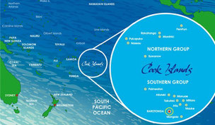


Air Tahiti flies only once a week to Rarotonga with a limited number of passengers due to the length of the flight and the weight of the aircraft - there are only 28 passengers on board. We land in Avarua, the capital town of the Cook Islands. Rarotonga is the main - and with a bit more than 10,500 inhabitants the most populous - island of the Cooks. The Cook Islands are in free association with New Zealand and therefore we switch language again.
The British navigator Captain James Cook arrived first in 1773 and again in 1777 - he named the islands 'Hervey Islands'. The name 'Cook Islands', in honour of Cook, appeared about fifty years later on a Russian naval chart.
The ringroad is approximately 30 kilometres long. There are two public buses which circle the island clock- and anticlockwise. It takes us about 20 minutes to get from the airport to Muri Beach, where our accomodation is.
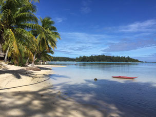
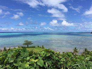
At Muri Beach (pic. 3) the lagoon, which surrounds the island, is at its widest and deepest. The following five days for us are snorkeling, reading, canoeing and taking kitelessons. Right next to our hotel there is a Night-Foodmarket with many different foodstands. We appreciate the get-together of locals and tourists.
We hire a car and circle the island twice and visit the maritime museum. It's there that we see a living stonefish and again we know why we always wear beachshoes in the waters of the South Pacific.
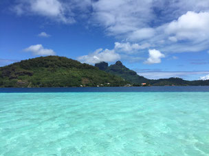
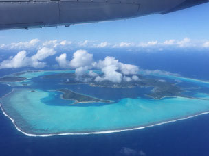
After five days we fly to Aitutaki, the second most visited island of the Cooks - especially by honeymooners. Approximately 2,000 people live on this second most populated island. Aitutaki is said to be the most beautiful lagoon on this planet. The island's size is only 18 sqkm - but the lagoon triples this size. The approach after a forty-minute flight is stunning - greens and blues in all different shades. Wow!
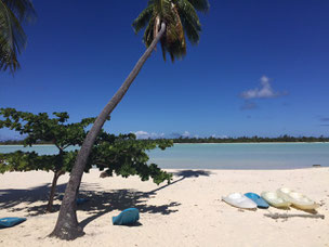
We stay in a bungalow right on the beach (pic. 4). Once again - a great choice! There is only one other Swiss couple in the other bungalow. We appreciate their company very much - but also the privacy of the two bungalows.
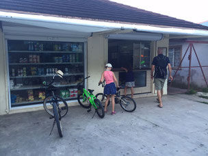
With our two scooters we explore Aitutaki and do our daily shopping. The supermarkets are a bit bigger than the ones in Maupiti, but still quite limited. In every supermarket we ask for fresh tuna. Not easy - but we don't give up. Someone tells us that we should ask for Kimberly at the gasstation. Her husband is a divemaster and might also be a fisherman. Good hint - the following day we get two kilos of fresh tuna. We enjoy Sashimi on our veranda with an excellent view on the lagoona. Great!
You can't leave Aitutaki without having done one of the lagoontours. First, Kuna takes us to an excellent snorkelingspot (pic. 5) and indeed: we have never seen such giant clams before and the water is crystal clear with plenty of colorful fish. We are overwhelmed.
A long sandbank takes us onto honeymoon island. Kuna explains that there are normally many weddings but today doesn't seem to be a good day for weddings. We are almost the only people on the island. After another magnificent snorkelingstop, we enjoy a delicious lunch on 'One Foot Island'. During lunch, Kuna tells us vividly about the shootings of the US-Reality-Show Survivor back in 2006. The British version of the show - shipwreck - was filmed here even six times.
We enjoyed our stay on Aitutaki very much - we could have stayed longer. But on the other hand: after almost 6 weeks relaxing in the South Pacific we are looking forward to a bit more active travels.
Kiwis - we are coming...
French Polynesia
Ici, on parle français! We have to switch languages which is not that easy as we got very used to Spanish in the past two and a half months.
We spend our first week in French Polynesia on Mo'orea, which means 'yellow lizard'. Mo'orea is only seven kilometres northwest of Tahiti and therefore only a short flight. Unfortunately, the weather isn't as sunny as we expected it to be. People on the island are talking about taking precautions because of a cyclone expected in a few weeks from now.
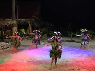
Luckily, we stay in a very nice villa with a pool. The kids do some work for school and we enjoy reading and relaxing. We visit a Polynesian Cultureshow at the Tiki Village (pic. 1) and spend a great evening there. The girls have tried to do the Polynesian Dance ever since and they make quite progress. We circle the island several times with our rented car: Belvédère-Lookout, which affords splendid panoramic views of Opunohu and Cook's Bay and we visit a turtle- and dolphin station.
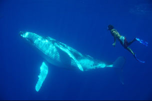
We wait for a perfect day for THE tour on this island - snorkeling and swimming with humpback whales! Every year humback whales come from Antarctica to French Polynesia to deliver their calves in the warm and protected waters of Tahiti. The peak season is between mid-Ausgust and the end of October. We start our tour with some snorkeling within the lagoona (pic. 2). We are able to touch sting rays while getting some information from our tour guide about these funny looking animals. On our way out to the deep blue sea, we are escorted by some curious dolphins.
Once we have passed the outer reef the boat ride gets quite bumpy. Our tour guides watch out for some signs in the water - there! There is a humpback whale - quick! Fins and goggles on, snorkel in and off we go! What we then experience has to be described as 'magical'! Deep blue water and beneath us a humpback whale turning once around its axis. Such a beautiful and peaceful moment. Far too soon, we have to return to the boat. The sea is very rough, the girls are not allowed to swim in the open sea, which is the right decision. After fifteen minutes, we see a female whale with its calf. As the sea has gotten very rough now, only the tour guide, Christian and another tourist dare to return to the open sea for a further snorkeling trip. But it's well worth the effort. Pictures you will never forget! The picture (#3) on the left is from the internet but it's exactly the way it is. Great, don't you agree?
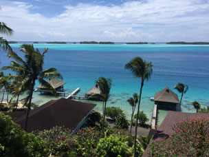
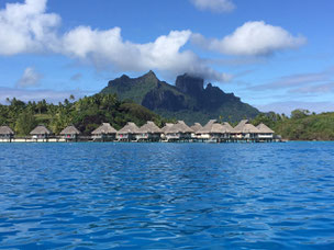
After seven days, we fly to Bora Bora. Moorea is beautiful but Bora Bora is the pearl of the South Pacific. As we arrive by plane the view says it all: a ring of sand-edged motus (islets) encircle a glinting turquoise lagoon around soaring rainforest-covered basaltic peaks. The first European sighting was made by Jakob Rogeveen in 1722. James Cook sighted the island in 1770 and landed later that same year.
Maupiti! - We like Moorea, love Bora Bora but in Maupiti we will lose our hearts...
Alain and his wife Nung, the owners of our accomodation, welcome us on the jetty. First, they drive us to the biggest supermarket on the island. We are surprised by the size of the market. Window shopping has become a new meaning. We tell the shop assistant our wishes through a window and some of the items are available, others not. The stock is quite limited: only two different choices of jam, Kellogg's Cornflakes only, one kind of cheese: cheddar and so on. It's different as in Bora Bora and we like it right away! (pic. 10)
We have an outstanding accomodation. One of only two bungalows right on beautiful Terei'a Beach. White sands, some palm trees and a beautiful view on the motu opposite. The picture (#11) is taken from the veranda. We can walk accross the lagoon to the motu. The water is shallow but only a few metres to the right there is a small reef for snorkeling. Everything is provided by Alain and Nung: bicycles, canoes, fins, snorkeling and surfing gear even harpoons. Instead of catching fish ourselves, we appreciate Alain's offer to organise fresh tuna from a local fisherman. Nung shows us the best way to prepare it - some sesame oil, ginger, capsicum and lime. What a nice gesture and it tastes heavenly.
Alain an Nung are great hosts. One day, Nung takes us and the Finnish couple from the other bungalow - Mika and Paulina - out on the reef for collecting some clams. We eat them right out in the reef with some lime and chilli and standing in the water - delicious and never tasted so fresh.
As the supplyboat for Maupiti hasn't arrived on time, we aren't able to get fresh drinking water, either. We start brewing tea and drinking fresh coconutmilk from the coconuts found around the house. We also start baking our own bread and collecting the passion fruits behind the house. We really like this way of living a lot and the only clothes we need these days are our bathers.
The seven days are over far too soon. For us, THIS is the true and ultimate paradise. We are so grateful to the people of Maupiti that they have voted to keep it that way by banning the construction of any major hotel in a referendum some years ago.
We spend two nights in Papeete as there is only once a week a flight to Rarotonga - our next destination.
Au revoir Tahiti!
Rapa Nui - Easter Island


'iorana Rapa Nui
Easter Island - a place we wanted to visit so dearly and ... we won't be disappointed! What an island! The island though is quite small - only 163 sq km - but famous all over the world for its almost 900 statues, called Moai. In 1995, UNESCO named Easter Island a World Heritage Site, with much of the island protected.
After a six hours flight from Santiago de Chile we land not only on the longest and widest runway of South America but also on an island, which claims to be the most remote place on earth.
By the time Jacob Roggeveen encountered the island on Easter Sunday in 1722, the island's population had dropped from 15.000 in the previous century to 2.000 - 3.000 people. European diseases and Peruvian slave raiding further reduced the Rapa Nui population to a low of only 111 inhabitants in 1877. Today's population is a bit over 6.000 residents, of whom 60 percent are descendants of the aboriginal Rapa Nui.
The first passenger aircraft landed 1967 and even today there's only one (sometimes two) flight per day. Our B&B host welcomes us at the airport with a Lei. We have arrived at the southeasternmost point of the Polynesian Triangle, where Leis are very common. We appreciate this gesture and realize that the culture has changed and that people are different from the ones on the Chilean mainland.
Our B&B is only a few minutes outside of the 'main city' Hanga Roa with a beautiful view on the harsh coastline. Stormy weather conditions on the first day - but the following days are nice and sunny.
We hire a small Jeep and explore the island. It takes about an hour to circle the island by car - we shall do this more than once the following five days.
We agree - if Rapa Nui was a cocktail, the ingredients would be as follows:
2 cl South Pacific
2 cl Scottland
a touch of volcanic rocks
3.000 brown horses
filled up with water in all possible shades of blue
... well shaken and decorated with some moai - cheers!
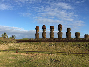
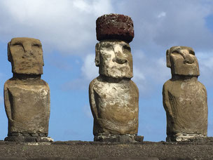
We are fascinated by the moai. We have seen the pictures many times back home and hoped that we won't be disappointed. But believe us - we are overwhelmed and deeply touched by these mystic and amazing stone figures. We especially fall in love with the fifteen moai in Tongariki. It's them whom we visit every day at all possible times - even for sunrise.
The moai at Anakena are impressive as well. Anakena is the only sandy beach of Rapa Nui. It's a very nice beach with deep blue waters. Many people take a swim but the water is still quite cool.
Rano Raraku is the place where all moai were made; we call it the 'moai factory'. At this moai quarry, the moai were first carved in relatively horizontal position into stone and then torn into a hole in the soil in order to rise them and finish the work on their back. Nowadays, only the heads are visible; the rest of the bodies are beneath the surface. The head measures one third of the total hight of a moai. The tallest moai erected was almost 10 metres high and weighed 82 tons. Why the production of moai, who represent deceased ancestors and former chiefs, had stopped all of a sudden, is not known.
The moai are great and certainly the main attraction of the island. But there is far more to discover. Rano Kau with it's stunning caldera is outstanding. The crater is almost a mile across and has its own micro climate. The crater lake has evolved a biotope and is one of the island's three natural bodies of fresh water.
On the third day we climb the tallest mountain (probably rather a hill) of Rapa Nui; Maunga Terevaka. Especially our younger looks forward to this hike as it reminds her of our local mountain back home. It is less steep than 'our hill' in Switzerland but quite similar though. On top of Terevaka (504 metres above sealevel) the view is fantastic and we are able to see the curvature of the earth clearly. Our picnic tastes heavenly and we feel a bit like Robinson Crusoe.
We got quite addicted to Rapa Nui. The people are 'very easy going', the scenery is breathtaking and searches its kind in the world and ... there aren't many tourists. The very expensive flight to Rapa Nui was worth every penny and we hope to visit this remarkable and unique place again some time in the future.
'iorana
Chile


Calama in the Atacama Desert is one of the driest cities in the world with average annual precipitation of just 5 mm. We are now on 2,260 metres.
Calama is not a touristic place and the most interesting place to visit is Chuquicamata; it is the largest open pit copper mine in the world. The pit is 4.3 km long, 3 km wide and over 1 km deep (pic. 1). We book a tour which is perfectly organised by the operating mine company COLDECO. First, we visit the original minig settlement which is very close to the mine itself. Because of health concerns the company had to shut down the village and all the families were located to the city of Calama where new houses were built for the employees and their families. Today, the village is a ghost town and can only be entered with a booked tour.
The pit itself is impressive; special trucks (pic. 2) are cruising along the dirtroads of the pit. One of these giant trucks costs 10 MUSD and one single tyre 40.000 USD. 5000 litres of diesel for one tank filling - there are eight fillings necessary per day. The pit is operated 24 hours a day all year round. In 2018 this open mine will be closed and changed to underground mining.
We switch to our slightly smaller truck - an Amorak VW and drive to San Pedro de Atacama which is only 100 km southeast of Calama. San Pedro de Atacama is a nice town with loads of backpackers either arriving from - or heading to - the Uyuni Desert. There is a pedestrian zone with lots of souvenir shops, tour operators and travel agencies and restaurants (pic. 3). We like the hang loose spirit of the town.
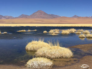
There are several lagunas in driving distance. Laguna Miscanti and Laguna Miniques are extremly beautiful and impressive. The colours of the Atacama Desert are difficult to describe but we are taken in by the scenery. There are hardly any tourists - one couple with a camper from France and one or two curious foxes.
Laguna Chaxa is best visited at sunset. As the sun sets, all the flamingos are returning to their nests which are very close to the visitor center (pic. 4). Again, we love the width and the colours of this unique place.
You don't have to travel to the Dead Sea to experience floating in salt water. With a salinity of more than 30% you float on the surface of Laguna Cejar. The entry is rather expensive - 21 USD for an adult and 3 USD for a kid, but the shower cabins are brand new, very clean and well worth the money.
El Tatio is the highest-elevation (4,320 metres) geyser field in the world and the largest in the southern hemisphere. The best time to visit the over 80 active geysers is early in the mornings to see them all steaming in the cold air. We aren't early birds and the drive to this geyser field is long and of such beauty that we take our time and take pictures (pic. 5) - the route is the goal. We return to San Pedro and for the perfect sunset we visit Valle de la Luna which is very close to the town. The given name of the valley isn't coincidental; wind and water have carved various stone and sand formations, similar to the surface of the moon.
Speaking of the moon: San Pedro de Atacama is famous for sky observation. Unfortunately, the best equipped observatories aren't open to the public. But there are smaller, more private tours available - our tour guide that evening is an astromener from the United States. The telescopes are big enough to see Saturn and its rings, various well known stars and the surface of the moon. The picture you see on the left is taken with our iphone through one of these telescopes. The tour is very informative and we feel the passion of the astronomer for the skies in the Atacama Desert. The remark that there are more stars in the universe than grains of sand on earth will be on our kid's mind for the rest of our journey, probably of their lives.
Initially, we wanted to drive from San Pedro to Laguna Blanca y Verde in Bolivia which are only a few kilometres off the boarder. Bad news for us - we are not allowed to take the car across the boarder. Worst case: the officers confiscate the car. We aren't looking for trouble. We try to book a tour which starts at USD 700 - crazy. This is not within our budget - this has to be postponed for the moment.
After five days we drive back to Calama and fly to Santiago de Chile, the capital of Chile. Once again a breathtaking flight: beautiful view on San Pedro, the Salar de Atacama and the Andes.
The first three nights we spend on the Pacific Ocean in Valparaiso, a seaport (pic. 7) about 100 km northwest of Santiago de Chile.
On our antique globe back home (designed in 1905) are the most important ship connections of that time drawn. Valparaiso played an important role in the second half of the 19th century, when the city was a major stopover for ships travelling between the Atlantic and the Pacific Oceans by crossing the Straits of Magellan. This made the city flourish and gain wealth. The opening of the Panama Canal hit the economy hard.
In the past few years Valparaiso has become popular for tourists. The city is built upon dozens of steep hillsides overlooking the Pacific Ocean and is declared a world heritage site based upon its improvised urban design and architecture. Our BnB is situated on one of the forty-two hills which circle the bay of Valparaiso - Playa Ancha. From our room we have a fantastic view on the colonial houses nearby, the city and the Pacific Ocean. Street Art and thousands of graffitis are found everywhere in the streets of Valparaiso. Our camera loves them!
South of Santiago de Chile is one of the famous wine regions of Chile, the Colchagua Valley. The landscape reminds us of the Ticino, the southern part of Switzerland. We visit the winery Viu Manent (pic. 8) and make a tour on a hackney cab which takes us along different vine stocks. While we are enjoying the winetasting, the girls have fun with the five puppies on the property. Viu Manent Carménère is our favourite wine of the day. Cheers!
Santa Cruz is the main village of the area with some very well perseved colonial houses. As in many other South American towns and cities the Plaza de Armas is very well kept and has many nice and historic buildings nearby.
The last three days we spend on mainland Chile is in Santiago de Chile. We enjoy the view from Cerro San Cristobal (pic. 9), do some window shopping and visit the Museo Interactivo Mirador which was great fun with loads of scientific experiments for the young and a bit less young ones.
To sum up, we only regret not having spent more time on the northern coast of Chile. Do you miss Patagonia? This will be a journey of its own some time in the future.
Bolivia
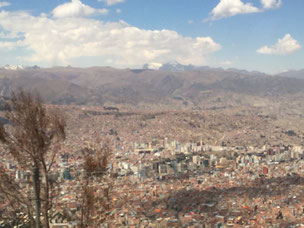


We enter Bolivia on land. The border crossing is fast and without any delay. La Paz city sits in a bowl surrounded by the high mountains of the altiplano (pic. 1). As it grew, the city of La Paz climbed the hills, resulting in varying elevations from 3,200 to 4,100 m. Our hotel is very close to the bus station and we pay the taxi driver way too much for the short drive.
As there aren't any 'must sees and dos' for us in the city, we flee to the countryside again. We visit Tiwanaku, which is the most important and oldest historical site of Bolivia. The ruins are up to 3000 years old. Unfortunately, a lot has been destroyed by the Spanish Conquistadors. It isn't the first time that we hear this.
The flight to Sucre (pic. 2) is very cheap - only USD 50pp - and this saves us a 12 hour bus ride. Sucre is the capital of Bolivia and the climate is much milder than in La Paz. We change to flip-flops and enjoy the warmer temperatures. Sucre is a colonial city with a well-preserved downtown and buildings from the 18th and 19th centuries. Most houses are painted in white - which gives the city a nice and clean touch.
We visit the local market and enjoy the various cafés along the main square. We even taste some Bolivian chocolate which tastes almost as good as the Swiss.
We take the bus from Sucre to Uyuni; this is a whole day trip. The scenery is breathtaking. We pass Potosi which claims to be the highest city (4,090 metres) in the world. From the bus, we are able to see 'Cerro Rico' - a mountain which is said to be 'made of silver'.
Arrival time in Uyuni is shortly before sunset. Uyuni has a population of bit more than 10,000 inhabitants and is visited by many tourists as the city is the gateway to the famous Uyuni salt flats nearby. We have to change our shoes again - it has become chilly and we are again at 3,700 m.
A once in a lifetime journey asks for a once in a lifetime hotel. Hotel de Sal Luna Salada (pic. 3) is about 40 minutes north of Uyuni in Colchani. Everything is made out of salt: walls, floors, tables & chairs even our beds. Very special and we like it!
We book a private day tour onto the salt flats. First we see some 'Ojos del Sal' which are outlets for subterranean rivers flowing beneath the surface. There's also a place where we can see how the salt bricks for housing construction are gained from the desert. Later, we race with our SUV Toyota 4x4 to 'Isla Icahuasi' which is an acient coral reef and hosts gigantic cacti. The drive is fantastic: white, flat landscape with some hills at the horizon (pic. 4). While we take a hike through the fantasy like landscape of Isla Icahuasi our driver prepares one of the most delicious meals we have had in Bolivia.
We all know the funny pictures which are taken in the desert. We cannot resist either and take one, two, three ... endless pictures (pic. 5) . It's a whole lot of fun!
The girls enjoy collecting salt crystals in one of the 'Ojos del Sal'. Our driver and tour guide is great and he loves the Uyuni salt flats - we can feel that. He recommends that the best time for visiting the Uyuni is March or April when the surface reflects in the thin waterlayer on the flats. We postpone this to a later expedition.
The extraordinary tour ends after an amazing sunset in the desert (pic. 6)! Certainly an A+ Day :-)
Many tourists do a three days tour in the Uyuni desert; starting in Uyuni and ending up in San Pedro de Atacama (Chile) or vice versa. For us, travelling with children, this seems to be too streneous. Instead, we decide to take the regular bus to Calama/Chile. There are only two buses a week to Chile and they leave Uyuni at 4 o'clock in the morning. We have never been so cold before whilst waiting for the bus to pick us up on a corner in the middle of the night. The ride itself was like travelling in a freezer. We are the only Europeans on the bus and the border crossing is much more complicated than from Peru to Bolivia. It takes us several hours and each luggage is checked carefully. Did we really think that a tour from Uyuni to San Pedro in Chile would be more streneous? Probably not - this ought to be checked out.
We arrive in the city of Calama/Chile in the afternoon.
Peru


A five hours flight along the Andes takes us from Panama City to Lima, the capital of Peru. Lima is a huge city and we stay in Miraflores which is quite nice and - even more important - safe. Two days later we start our tour by taking a bus to Paracas. Travelling by bus is the easiest and most common way to travel in Peru. We highly recommend the company 'Cruz del Sur' as the buses are more or less on time, clean and very comfortable. We also appreciate the saftey measures which are taken; photos and videos are taken of every passenger and the drivers swap every four hours.
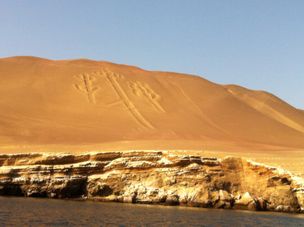
We reach Paracas after a four hour drive. Paracas and its islands 'Islas Ballestas' - also known as the poor man's Galapagos - is very dry but beautiful. The scenery reminds of the Red Sea. On our boat trip to the Islands we see our first geolyph - the Paracas Candelabra. The Islas Ballestas are home to sealions, pinguins and one million(!) cormorans. We are even lucky enough to see some dolphins on our way in. It is the first time that our girls see a living dolphin. What a day!
It's only a short drive by taxi or bus to Ica and the Oasis Huacachina. Sandboarding in the sanddunes and the buggyride are fantastic and a thrilling experience. Don't miss it!
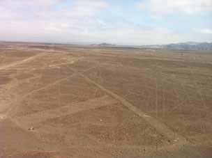
Another 'Cruz del Sur' busride and we arrive in Nazca - world famous for its lines in the desert. We don't take a plane to see the lines from up in the air, we take a taxi. The driver takes us to two 'miradores' and we are able to see 'the hand', 'the tree' and a few more even without being up in the sky. The lines were first rediscovered after commercialized flights have flown over the plateau. Maria Reiche (1903 - 1998), a German mathematician did a lot of research on these lines and had success in gaining recognition and preservation of the property. In 1995 the Nazca Lines were declared a UNESCO World Heritage Site. We visit Maria Reiche's home which is a museum these days. Maria Reiche was really taken in by the Nazca lines - her whole life was dedicated to study them.
Our first - and only - overnight busride takes us to Arequipa at 2400 metres above sealevel. We stay in Arequipa five nights in oder to get acclimatized. It's a nice city and is Peru's second most populous city with almost 900,000 inhabitants.
The Santa Catalina Monastery is a city within the city of Arequipa and well worth to visit. The tradition of the time during colonization indicated that the second son or daughter of a family would enter a life of service in the church. The monastery accepted only women from upper class Spanish families and each family paid about USD 150,000 dowry. The wealthiest nuns were even allowed to have their own maids. In 1871 Sister Josefa Cadena, a strict Dominican nun, was sent by Pope Pius IX to reform the monastery. She sent the rich dowries back to Europe, and freed all the servants and slaves, giving them the choice of either remaining as nuns or leaving.
One of our best tours in Peru starts at 3 a.m. in Arequipa; quite an early wake up call. It takes us more than four hours to get to the Colca Canyon by bus in order to see Condors flying above one of the deepest canyons (depth: 3,270 m) in the world. On our way, we almost reach the 5,000 metres above sealevel mark and we feel it; air has become thin and thinner. But the scenery is breathtaking and we fall in love with the Peruvian pampa and the hundreds of Alpakas. In the evening we return to Arequipa, it has been a long day and worth every minute.
After spending five days in Arequipa we fly to Cuzco - we are even able to locate the Cañon de Colca from up in the air. Cuzco is a very picturesque and currently the most important tourist destination in Peru. The site of Cuzco was the historic capital of the Inca Empire from the 13th into the 16th century until the Spanish conquest. We feel the additional 1000 metres and get some headache for the first twenty-four hours; but after one day we are all fine.
Leaving Cuzco after three days we reach Aguas Calientes by taxi and the famous Peru Rail. Aguas Calientes is the closest town to Machu Picchu which is situated only 6 kilometres up the hill. Aguas Calientes is a very busy location with loads of tourists and many restaurants and hotels. Machu Picchu is said to be the nicest at sunrise. Therefore, we get up at four o'clock in the morning in order to queue up for the bus which takes us up to the ruins. We are not the only people who got up in the middle of the night but it is all very well organized and somehow we manage to be at Machu Picchu by sunrise. Machu Picchu is an extraordinary and mystic place. We are totally captivated by its beauty. We sit - 'at our site' - for hours just enjoying the magnificent views. At 5 p.m. the park closes and we return to Aguas Calientes. Machu Picchu is the highlight of our journey so far.
After another overnight stay in Cuzco we continue our travel to Puno on Lake Titicaca. Our hotel is on a hill just outside of Puno with an outstanding view on the lake and its surroundings. Lake Titicaca is often called the highest commercial navigable lake in the world, with a surface elevation of 3,812 metres.
We visit the Uros which are pre-Incan people who live on forty-two self-fashioned floating islands only about 5 km from the shore of Puno, the largest city on Lake Titicaca. The Uros tell us how they build their houses, boats and islands out of reed. It takes 15 months to build a new island. It's very interesting but also very touristic and commercialized. After two hours we return to Puno and on our way back we can see why Lake Titicaca is said to be very polluted.
We take the bus from Puno to La Paz, the capital of Bolivia, which is a beautiful busride along Lake Titicaca. The border crossing is very convenient, fast and relaxed. We've expected it to be more stressful.
We've spent three weeks in the southern part of Peru and are very much impressed by the scenery, culture and its people. This is certainly a country we would like to visit again in the future.
Panama City
It is a one hour flight from San José to Panama City. As we are approaching the city, we are already able to get a glimpse of the Panama Canal. This Canal is the main reason for us visiting Panama as it is named to be one of the seven wonders of the modern world.
Panama City is the largest city in Panama and is home to almost half of the 3.9 million people living in Panama. With the help of the United States, Panama seceded from Colombia in 1903, in return the US were allowed to build the Panama Canal between 1904 and 1914. By the end of the 20th century, the United States had to transfer the Canal back to Panama.
The past presence of the US is still noticeable: it takes us more than 2 hours to pass immigration and the currency in Panama is still the USD.
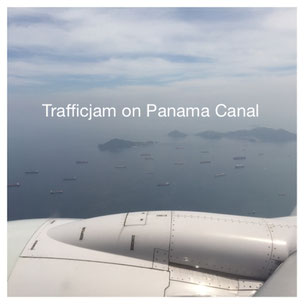
As we are particularly interested in the Panama Canal, we have chosen our hotel right on the Canal. At all times, we see big containerships passing which is most impressive at night.
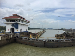
Our first intermezzo with the Canal is the great Panama Canal Railway. We take the bus to Colon - which is on the Carribean side of the Canal - hop on the train and enjoy the scenery and atmosphere along Lake Gatun and the Canal on our way back to Panama City. Lake Gatun is an artifical lake and part of the Canal; it is 26 metres above sea level. The Panama Canal Railway was very important for the successful construction of the Panama Canal which was opened in August 1914. Annual traffic is nowadays up to more than 14'000 vessels. The largest ships that can transit the canal today are called Panamax. It takes 6 to 8 hours to pass through the Panama Canal.
On Saturdays, it is possible to do a half way transit by ship; we surely want to do this. We pass three locks together with the containership Mare Tracer. The most famous locks on our passage are probably the Miraflores Locks where vessels are lifted (or lowered) 16.5 metres in two stages. It takes us severeal hours to do the half way transit but it is very interesting and a 'once in a lifetime' experience.
Panama City itself is a city like most other big cities in the world. The historic quarter with its colonial houses is quite picturesque and the 'Ceviche' at Panama's wharf was the best raw fish we have had so far.
After five days we leave Panama and head to Peru.
Costa Rica


Costa Rica is our first destination on our round the world trip and it turns out to be a good decision. Although we know some bits of Spanish we are relieved that most Ticos speak Englisch a little.
In San José we rent a 4x4 SUV and head to the Carribean Coast of Costa Rica. Tortuguero is a quite remote village and can only be reached either by boat or plane. We take a speedboat which turns out to be a fun ride along the mangroves. Tortuguero NP is famous for its wildlife; especially for the giant green turtles.
We book a tour to watch the turtles as they are coming out of the sea to lay their eggs into buried nests. Unfortunately, it is full moon and the bright light keeps many of the turtles from getting onto the beaches. But we are lucky and we see two or three turtles. The whole trip is quite strenuous - especially for the girls: we hike through the dark rainforest for about one and a half hour return at 100% humidity and approx. 30 Degrees Celsius. But nevertheless, it was well worth it and the sounds of the jungle are still with us.
Three days later we switch to the Pacific Coast which is the nicer coast, as we believe. Manuel Antonio NP is quite touristic but it's really a special moment when you see a sloth hanging up in the trees for the first time. The sloths don't seem to be bothered by the tourists much. 'Hang loose' at its best! The beach at Manuel Antonio is really nice and invites us for a quick swim - but watch out for the poisonous trees along the beach!
Our drive to Bahia Drake in the south of Costa Rica is very adventurous but also enjoyable. The last 30 kilometres are on gravel. The holes in the road are quite heavy, so take your time. There are also some rivers to cross - either on 'bridges' (2 panels placed in the distance of the wheels - OMG!) or you have to steer the car in and out of the water. Both options keep your heartbeat on a higher pace but on the bottom line it is also fun to do. I takes us two hours to get to Bahia Drake and in the end it was worth every single bump. Bahia Drake is like paradise!
We stay at Bahia Drake for two nights and enjoy 'the treasure of Sir Francis Drake'. Wildlife is amazing; parrots flying as we have never seen before. We could have stayed here for longer, but the journey continues.
Monte Verde is the cloudforest region of Costa Rica. Santa Elena is the main village at Monte Verde and packed with Backpackers. We enjoy the international atmosphere and do some hiking in the rainforest. The temperatures are nice - not as hot as the previous days.
Volcano Arenal is only a hundred kilometres away but it takes us four hours to reach our destination due to the bad roads. Arenal is a real beauty among the volcanoes. Its shape is very conical and symmetric. Unfortunately we are not lucky enough to see the volcano without clouds covering the top - but it is still nice to look at.
We spend our last five days a five minutes drive north of Tamarindo in a place called Brasilito, Playa Conchal. The beach is gorgeous, clear waters and plenty of shells for the girls to collect. Swinging in our own hammock we enjoy the sun of Costa Rica and get prepared for our next destination - Panama City.